Cornerstone guide
Pagosa Springs neighborhoods and surrounding areas explained
Town, Pagosa Lakes, Aspen Springs, Highway 84, Chromo, Arboles — and how to read a place before you fall for a view.
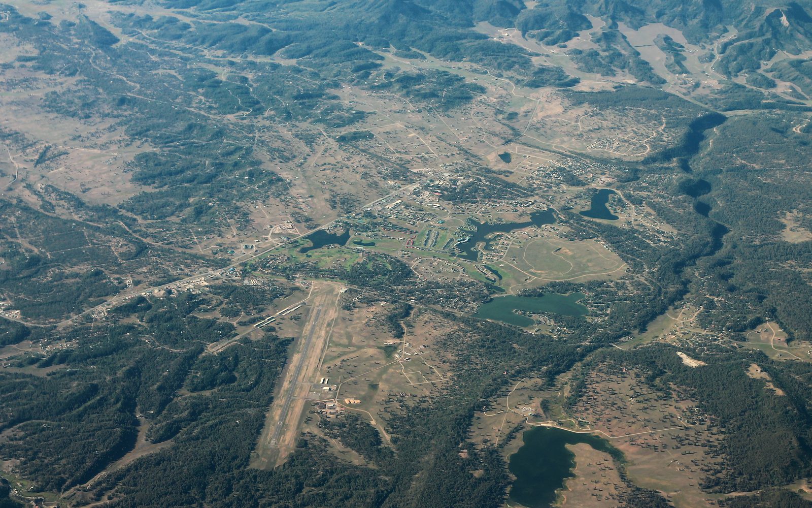
People ask for “the good neighborhood.” That is the wrong question here. Pagosa is not a metro with a school-zone hierarchy. It is a small town on a river, a large planned community with lakes, a gravel-road west side, a highway south toward New Mexico, and a lot of forest in between.
The right question is: what kind of day do you want on a Tuesday in February?
This guide walks the map town first, then west, then the highways, then the far places. It uses association names, Census place names, and county geography — not a ranked list of “best investments.” Where a detail comes from a marketing page rather than a government or association source, the writing says so or stays general.
How the map is actually organized
Two highways do most of the work.
U.S. 160 is the east–west spine. East takes you up the San Juan toward Wolf Creek Pass and South Fork. West takes you toward Chimney Rock, Bayfield, and Durango. U.S. 84 leaves town to the south and runs to Chromo and on toward Chama, New Mexico.
Most addresses that say Pagosa Springs, CO 81147 are not in the Town of Pagosa Springs. The town is the only incorporated municipality in Archuleta County. Unincorporated living is normal. Covenants, metro districts, and water districts are how services actually show up.
If you have not read wells, septic, propane, and roads, stop and read it. Neighborhood personality is often just a utility story with trees.
In town
Downtown is the river, the hot springs, U.S. 160, local government, and the version of Pagosa visitors can walk. The town is a few square miles. The 2020 Census counted 1,571 people inside town limits.
What you get in town that you do not get everywhere else: municipal streets, proximity to the high school and county offices, and a chance of walking to something. What you also get: traffic on 160, visitor seasons that change the noise, river-adjacent flood risk (see the October 2025 flood in the moving guide), and town short-term rental rules that are stricter than the county’s.
Town vacation rentals need a Town permit if you rent for fewer than 30 consecutive days. Those rules are not a casual add-on. They are covered in the second-home guide. If you are buying in town to “make it an Airbnb,” start there, not here.
Housing in town is a mix — older houses near the river, newer infill, small multifamily, and commercial mixed in. It is not one architectural story. It is a working county seat.
Pagosa Lakes and the PLPOA world
West of town, on the uplands people still call “the Lakes,” is the closest thing Pagosa has to a large planned community. The Pagosa Lakes Property Owners Association (PLPOA) describes itself as a covenant-controlled, mixed-use development: more than 6,600 properties, 27 subdivisions, about 21 square miles, surrounded on three sides by San Juan National Forest.
The administration office is at 230 Port Avenue. The rec center is at 45 Eagles Loft Drive. There are lakes, trails, and a golf-course landscape that reads as suburban-mountain to anyone coming from a larger city. A lot of full-time families live here because the driving is predictable and PAWSD water and sewer are the norm in the core.
That last sentence is the one that matters. You are generally buying into central utilities, covenants, an Environmental Control Committee, and an annual assessment — $365 per property for 2026, or $1,095 if the property is assessed as an STR, billed in January and due May 1.
PLPOA publishes individual subdivision declarations. Names you will see on plats include:
- Twincreek Village, Ranch Community, Pagosa Vista / Pagosa Trails
- Lake Pagosa Park, Lake Forest Estates, Lakeview Estates, Lakewood Village
- Martinez Mountain Estates, Pagosa Highlands Estates, Eaton Pagosa Estates
- Pagosa-in-the-Pines and Pagosa Pines Units 2–4
- North Village Lake, South Village Lake / Mallard Point, South Shore Estates, Ridgeview Estates
- Chris Mountain Ranch (35-acre parcels) and Chris Mountain Village Unit II
- The Enclave at Aspen Village, plus townhome and condo regimes (Alta Vista, Aspenglow, Blue Horizons, Bristlecone Lofts, Cobblestone, Wedgewood, Timbers, and others)
PLPOA’s own list flags Pagosa Meadows (NOT PLPOA) as a separate thing from Pagosa Meadows Units 2–4 that are listed. That is the kind of footnote that bites people. “Meadows” is not one legal world. Read the declaration for the parcel, not the nickname on the mailbox.
Roads in much of this area are public, not association-owned. County Road and Bridge is in the snow conversation. That does not make every cul-de-sac equal in January. Lower, closer-in streets behave differently than a shaded north-facing lane up by the trees.
Condos and townhomes add a second association on top of PLPOA. Budget for both. Fishing and boating permits are a PLPOA desk item, not a vibe.
Pagosa Lakes is where a lot of ordinary Pagosa life happens. Covenants bother some people and reassure others. Many full-time residents would rather live with a design review than with a mystery well. That is a preference, not a ranking.
Aspen Springs
Keep going west on U.S. 160 and you are in a different philosophy.
Aspen Springs is a large 1960s-era subdivision on both sides of the highway, divided into six units (I–VI). The community’s own site says thousands of lots, originally platted in that era. This is not PLPOA. Protective covenants are not the organizing idea. There is a voluntary property owners association in local description; do not buy on the assumption that someone else will enforce your neighbor’s taste.
What you should assume until the parcel proves otherwise: gravel roads, no central water or sewer, well or cistern, septic, and more independence than the Lakes. Some of that independence is why people love it. Some of it is why a buyer from a HOA suburb lasts one winter.
Mineralized well water comes up in local conversation here more than it does in PAWSD country. Test. Do not take a listing’s word that the water is “fine.”
Aspen Springs can be a good value if you want space and can run rural systems. It is a bad value if you thought you were buying Pagosa Lakes without the dues.
South on U.S. 84: acreage, horses, and Chromo
Highway 84 is the road toward a bigger sky. You leave the lakes-and-golf visual language and get meadows, ridges, and longer views.
Loma Linda is a large, established acreage area about six miles south of town that local marketing writeups describe as typically a few acres per parcel, horse-friendly, with central water and septic, and electric service. Those lot-size and utility details are not treated as official here because they were read on marketing sites, not on a district or county neighborhood plan. The name is real. The character — more space, still a reasonable drive to town — matches what you see on the ground. Verify water, septic, covenants, and horse limits on the specific parcel.
Farther south, Chromo is an unincorporated community and post office (ZIP 81128) about 24 miles down U.S. 84, at 7,284 feet per GNIS. The Little Navajo and Navajo Rivers run through it. Explore Pagosa is right that the drive itself is part of the place — Coyote Park, old railroad grade, migration routes in spring and fall. Elk on the road are not a metaphor.
Chromo is access to the South San Juan Wilderness more than it is a suburb of Pagosa. If you work in town every day, 24 miles of two-lane in January is a lifestyle. If you came for quiet and wildlife, it is the point.
East on U.S. 160: toward the pass
East of town the river and the highway climb toward Wolf Creek. This is the pretty drive people remember.
San Juan River Village (you will also hear San Juan River Resort) sits about six miles east in local descriptions. Marketing pages say smaller wooded lots, a POA or metro district, community water and sewer, and private fishing access. Again: the place is real; the amenity list should be confirmed from the association or metro district, not from a summary of someone else’s listing copy.
Higher and more private ranch-style developments exist along this corridor. This guide does not inventory gated names from sales pages. If a gate and a private road are the product, budget for the road and for winter access as if you were buying a small utility company.
Wolf Creek Ski Area is 23 miles from Pagosa. Living east of town shortens that drive and lengthens the town drive. Families who ski 40 days a year care. People who go to the high school play on a weeknight care in the other direction.
West toward Durango: Chimney Rock, and then the lake country
U.S. 160 west is not just Aspen Springs. You are heading toward Chimney Rock National Monument — 4,726 acres of San Juan National Forest between Durango and Pagosa, designated on September 21, 2012. It is a Pueblo II / Chacoan outlier landscape, day use, generally May 15–October 15, with an activity pass. It is a neighbor, not a subdivision. Living “out toward Chimney Rock” means you have chosen highway distance and a different quiet.
Keep going southwest via Highway 151 and you reach Arboles, a Census-designated place, and Navajo State Park. Colorado Parks and Wildlife puts the park 35 miles southwest of Pagosa Springs and 45 miles southeast of Durango, at 1526 County Road 982, Arboles. Navajo Reservoir is about 15,000 surface acres and stretches 20 miles into New Mexico. This is water-recreation Colorado — boats, ice, wind, and a town that is not Pagosa.
If you buy in Arboles because you liked downtown Pagosa, you bought the wrong picture. If you buy there for the reservoir, you bought the right county and a different town.
Other names you will hear
Piedra is a river and a country west of town, not a single HOA. Stevens Field sits just west of town off Piedra Road / County Road 600. Lake Hatcher, Lake Pagosa, and Village Lake give the Lakes their name; lake access is not the same as owning lakefront.
Alpine Lakes Ranch and similar ranch-lot POAs show up in sales comparisons. Read that POA’s documents the way you would read PLPOA’s: water, road, covenants, assessments, and whether agricultural classification is actually available on that parcel.
A simple way to choose
Four filters work better than “north versus south.”
- Utilities. PAWSD and a permitted sewer tap versus well/septic versus cistern. See the systems guide.
- Covenants. PLPOA and town rules versus almost none. Neither is morally better. They produce different neighbors.
- Minutes to town and minutes to the pass. You can optimize one. Rarely both.
- Who you are in winter. A family with a high-schooler, a remote worker who needs uptime, a second-home skier, a retiree who wants the hospital close — those are different maps.
Buy the most boring well-functioning house that fits your week, in the part of the county that matches your winter. Views are cheap compared to a bad road. The cost guide will show you why a “deal” on ten acres can cost more than a smaller house on a paved street.
And if the house will sit empty 40 weeks a year, stop shopping neighborhoods and read buying a second home. Empty houses have a neighborhood too. It is called vacancy, and the 2020 Census already counted a lot of it.
Sources
- PLPOA home page: 6,600+ properties, 27 subdivisions, 21 square miles; 230 Port Ave; rec center 45 Eagles Loft Drive. https://www.plpoa.com/
- PLPOA governing documents page: list of individual subdivision declarations; Pagosa Meadows (NOT PLPOA) note. https://www.plpoa.com/learning-about-plpoa/public-disclosures/governing-documents/
- PLPOA annual assessment history: 2026 assessment $365 / $1,095 STR; 2025 $335 / $1,005. https://www.plpoa.com/learning-about-plpoa/public-disclosures/annual-assessment-history/
- Wikipedia, Pagosa Springs: only incorporated municipality; 2020 population 1,571. https://en.wikipedia.org/wiki/Pagosa_Springs,_Colorado
- Wikipedia, Archuleta County: places include Arboles (CDP), Chimney Rock, Chromo. https://en.wikipedia.org/wiki/Archuleta_County,_Colorado
- Wikipedia, Chromo, Colorado: unincorporated; ZIP 81128; elevation 7,284 ft; post office since 1885. https://en.wikipedia.org/wiki/Chromo,_Colorado
- Explore Pagosa, Chromo: 24 miles south on U.S. 84; South San Juan Wilderness access. https://www.explorepagosa.com/chromo/
- Aspen Springs community about page: six units, 1960s platting, both sides of U.S. 160 west. http://www.aspenspringspagosa.com/about.html
- USDA Forest Service, Chimney Rock National Monument: 4,726 acres; designated Sept. 21, 2012; hours May 15–Oct 15; activity pass. https://www.fs.usda.gov/r02/sanjuan/recreation/chimney-rock-national-monument
- Colorado Parks and Wildlife, Navajo State Park: Arboles; 35 miles SW of Pagosa; 15,000-surface-acre reservoir; 20 miles into New Mexico; 1526 CR 982. https://cpw.state.co.us/state-parks/navajo-state-park
- Wolf Creek Ski Area: 23 miles from Pagosa Springs. https://wolfcreekski.com/the-mountain/
- Town of Pagosa Springs, Vacation Rental License: permit required for rentals under 30 consecutive days inside town. https://www.pagosasprings.co.gov/238/Vacation-Rental-License
- Explore Pagosa, Stevens Field: ~3 miles west of downtown; Piedra Road / CR 600 access. https://www.explorepagosa.com/getting-here-from-there/